Notes: I use the word "spark" for the Norwegian/Swedish
"sparkstötting" which is usually translated as "kick-sled"
For a description of spark see: Spark
"Kommune" is a municipal subdivision of a "Fylk" or county. Corresponds to a "township" in eastern US and Canada.
Gjøvik is still may favorite place to ski in. It is one of the 3 "Mjøsbyene" - the other 2 sister cities are Lillehammer and Hamar. Gjøvik is perhaps less famous than its sisters. If you are a fisher, you have probably used Mustad fish-hooks : the world's largest fish-hook factory is here. The Madshus ski factory is also in Gjøvik Kommune, at Biri about 20 km north of the city. Gjøvik Kommune (township) has a population of about 25000, 15000 live in the "city" area. Neighboring Toten Kommune has about 20000, most live in Raufoss.
Gjøvik has a smaller version of Oslomarka, maybe it is a little less rugged. Most of the lower areas are dairy farms- the landscape looks a lot like Vermont. Gjøvik has its own Skiforeningen with ties to Oslo's. I think their trail signs are the best; at each major trail junction there is a trail map (about 200 in all). Skiforeningen sells 4 trail maps (løypekart) of Gjøvik/Toten area. In addition I bought a "Tur-kart" (1:50000 topo) of Gjøvik area. It was printed in 1981 and may be out of print now. But the national map service (Statens Kartverk) is now publishing new maps in the Tur-kart series so there may be a current map out soon.
One thing about the trail system in Gjøvik is that is not a resort at all. Only locals (or visiting relatives, friends etc) ski here. So this is the "real" Norway, not a "made for tourists" ski resort. It's probably quite typical of towns its size; Hamar has excellent trails too, although the good ones are further from the town (a whole 10 km !)
The train arrived in Gjøvik about 1100. On Sunday morning there is very little open. I have read that some railway stations rent bicycles in the summer, so I was hoping, maybe, they also rent sparks (kick-sleds) in winter. That would have been convenient for carrying my large pack, day-pack and ski bags. No such luck here. The tourist bureau across the street does rent bikes in summer, but they are closed on Sunday.
A word about cash for Canadian (and US) visitors: I stopped at 2 "mini-banks" (ATM) downtown. The first one didn't accept my cards. The second one did. Most mini-banks will accept both VISA and bank cards at some time of the day. I guess the networks to the Canadian banking system aren't always open. But this is very convenient, one doesn't have to carry cash. It might be a good idea for you to bring some cash for the first day in Norway, until you find a mini-bank. There are mini-banks at Gardermoen airport and they did work for me on the first try.
So I started walking up the rather steep streets to Hovdetun Hostel (Vandrerhjem). It was lucky I brought my "ice-walkers" (studded soles that strap on to my boots) The sidewalks are very icy. But another way of looking at it is the sidewalks are "groomed" for sparks. I resisted the temptation to "borrow" any of the many sparks parked along the street.
If I had my ski boots on I could have skied part of the way. Just before I got to the hostel, I was passed by two girls skiing on the sidewalk. They asked me something in Norwegian and then in English:
"Where does the trail start?"
"Well I haven't been here in 3 years, but it used to start by the Tennis Hall, on the left -- I'll be coming up there in a little while too! -- GOD TUR"
Hovdetun Vandrerhjem is a nice place. Unfortunately it is usually full on Friday and Saturday nights with school music and sports teams. But everybody has checked out now so I get a 4 bunk room all to myself. I asked the desk lady about renting a spark. She didn't know anywhere but would ask the manager later.
Across the street is a huge hall with indoor tennis courts. On the other side is a park (FASTLAND) with a small (90 m ) slalom and snow-board hill. In the summer there is a big swimming pool and outdoor tennis courts. About 1 km away is the "mountain hall" - a large sports center dug under a mountain including skating rinks and swimming pools. Some of the semi-final hockey games during the 1994 Olympics were played here.
I quickly packed a lunch and put on my skis and skied across the street to the Tennis Hall. Right where I expected there was an old groomed track covered by about 10 cm of new snow. I didn't see any fresh tracks, I guess those girls followed the road up to the horse stables. It was easy breaking trail for about 30 seconds, then the snow-cat came by and I had a perfectly groomed, double tracked trail.
Actually not very many people ski the first 2 km to Eiktunet. There is a 100 m climb in the first km. At Eiktunet there is a large parking lot, where most people start from. There is a city bus running up there every 30 min., so it is possible to skip this climb. The snow is usually drier at Eiktunet (elev. 300 m).
But today it is a fairly easy climb. The trail runs along a residential area. Quite a nice trail to have in your backyard. Oh, did I mention that this trail is lighted up at night (lys løype) for the first 10 km?
At The Eiktunet parking lot I branched off to the Gjøvil Ski Stadium where the local children's ski races are being held, in conjunction with the Holmenkollen Children's day in Oslo. There are several hundred children (barn), aged 3 to 10, proudly skiing around the tracks with their medals around their necks.
Now the main trail is a fairly easy climb, with a few steep sections. I has been 3 years since I have skied here, but I feel like I have come "home", every bend in the trail seems familiar. Since this is Sunday, there are many people out, sometimes 3 generations of a family together, many pulling pulks. The trail is usually 3 lanes (passing lane in middle), but in open fields it is often groomed as a 4 lane "divided highway".
Then I come to the very nice Gjøvik Skistua, owned by the Gjøvik Orienteering Club. It is a more rural version of Kikutstua in Nordmarka. Too bad it is only open on weekends and school holidays. The two girls I met earlier had found the way, and were just finishing lunch. I buy the traditional solbaer drink and vaffel to supplement my lunch, and a few postcards. They also sell Skiforeningen trail maps and ski wax. Mounted over the fireplace are some very ancient but elegantly carved skis.
There was a TV on in the far corner and many people were watching it. Hey, it's a ski race- the 15 km classic WC from Finland. This is the only way to watch a ski race on TV: taking a break from a ski tour, sipping on hot solbaer! I only waited around to watch Erling Jevne finish at 39:07. He was well ahead so I thought he was a sure winner. It turned out that Bjørn Daehlie actually won in 38:48, which is unusual in a classic race.
Back on the trail it was snowing, sometimes quite thickly. It was fairly wet and my skis sometimes clogged. I have 10 cm graduations marked on my ski poles so I measured the snow depth in several places. It was around 120 cm deep. There are a lot of open fields around Vardal Kirk, with great views on clear days , but today it is low visibility, and windy so I quickly move along. I turn off to come back on the "Haug Rund" through Rødgardsmyra, an open bog. (myr == moor, mire, bog)
Skistua has closed when I get back, but I have a second lunch in the sheltered porch. Wet snow is coming down, quite thickly. But the track has been glazed, and it's mostly downhill so I double pole most of the way back to Eiktunet. It is interesting to watch the lights come on. Each light seems to be controlled by a photo-cell, so the lights in the dark woods come on first, later the lights in the open come on. During weekday evenings, this is where the local "night-life" is, the trails are really alive with skiers.
Past Eiktunet it is raining lightly. The lower part of the trail has also has some horse traffic on it (or maybe it was elk?). It is a little wild coming down the big hill to the tennis hall. So there's a really good snow base here, and fresh snow coming down. If it would only clear up and cool off, things would be perfect!
I didn't see any TV shots of Vasaloppet, which was today, about 200 km to the east. Later there was a big spread in the local paper (Oppland daily). A local skier did quite well, he said that conditions were slippery and his arms did a lot of work. "Smirre" had entered the race for the first time. It also mentioned that 30000 people had taken part in Vasalopp week events and that they expect that the quota for the 2000 Vasa will be full by April 1999!
I looked in a few ski shops and found out that most Madshus skis (including the Voss, which looks good) are actually made in the Czech republic! Only the high end Madshus are made at the Biri factory. I found some new topo maps for skiers and hikers (the Tur Kart series). There are now maps for Birkebeiner Løype and Hedmarks Vidda (area to the south of Birkebeiner)
Browsing through a bookstore I was lucky to find a copy of a recent edition of Roald Amundsen's "Sydpolen", on sale (88 Kr down from 248 Kr).I kept looking for "Den Evige Sne" (the eternal snow) a ski history of Norway by Tor Bomann-Larsen. No bookstore in Norway seemed to have it. I browsed through a copy of it in the library and it looked like I should be able to read it, with a help from a dictionary.
So it was after 1230 before I got my skis on and headed back up to hill. I put on a thick layer of violet extra since the snow was wet and slippery. I was breaking trail in about 5 cm of new snow and there was light snow falling and fog. Of course once I got above 300 m, the snow was drier and I had to scrape most of my climbing wax off. I ate my lunch outside in the woods near Eiktunet.
Just past Eiktunet there were lots of fresh elk (elg) (Alces alces, called moose in Canada) footprints and other "things" on the trail. They had been eating on the bushes along the trail. Another common animal here is the goat-sized roe deer (rådyr) (Capreolus capreolus).
At Skistua (elev 460m) I was in dense fog. I stopped for a snack and to plan a route from here. There are not too many people on the trail today, but the main trail has be recently trackset. I decided to turn north a trail towards Gubberud, which drops down over 100 m. I was breaking trail in about 10 cm of new snow. I turned around at the road crossing at the bottom. The climb back up wasn't very hard since I still had on very good climbing wax. My glide on the flats was very poor.
Back on the main trail there were more people but I still didn't have much glide on the gentle downhill to Eiktunet. Lots of people glided past me on the downhills.
I only did about 18 km this afternoon. I was quite wet when I got back.
In the morning it was about -5 C, and the sky was clearing. It looks like a great day coming! I could see across Mjøsa (lake); it is only about 3 km wide here. In the middle there were open patches and to the south it was all open water. In 1996 I skied all the way to Hamar, but I can't do that this year.
The conditions going up the big hill were crust with a little powder, but it was very easy climbing with my violet extra. After about 1 km I got to excellent dry snow. Just before Eiktunet, the snow-cat groomer passed and there was then an excellent track.
I noticed the fresh grooming turned off towards the Gjøvik Skistadion, so I followed them. There were tents, campfires etc. set up in the fields, and they were putting up flags at the finish line (Mål). It was a school ski day. These outdoor activities seem to be an important part of school. Just about every weekday I would meet school groups skiing, learning "snow lore", orienteering etc. This group seemed to be about age 10.
Back on the main trail it is is excellent +++ conditions - "silk conditions" is a common metafor they use here. To bad I don't have any glide. I stopped at Skistua (closed today) for a snack and to scrape off the violet wax, hoping to get down to the blue was underneath. It helped a little.
There were excellent views across the open fields at Vardal Kirk as the sun came out. To the east one sees Mjøsa and across the dale to the south the hills of Vardalåsen rise to about 600 m. I turned off at Haug to Rødgardsmyra (elev. 500m), and down to Glaestad (460m). Now there is a huge steep hill up across farm fields. They call it Solbakken, because it is a sunny hill. There is a little kaffee at the top, but it is only open on weekends. The trail then goes into the woods and climbs more to a junction. The trail to the right (Håkenstad 4.8 km) is new to me, so I take it.
The trail climbs to 600 m , then comes out of the woods for a spectacular view across Snertingdalen, a deep valley to the north. The opposite slope or "li" is dotted with farms, but the hills beyond rise to about 800 m. There is a separate map for trails on the north side (Biri- Stertingdal) which extends almost to Lillehammer. Some other time I hope to explore that region.
The trail descends nearly 100 m through open areas then starts climbing again through the woods. Then there is a fast long downhill back to the road crossing at Gubberud (380 m) where I was yesterday. I stopped for a second lunch in a sunny spot. There is a 100 m climb in the next 2 km, back to the main trail but conditions are excellent and my grip is good. There are a lot more people on the main trail past Skistua. Again I double pole on the gradual downhill, but still have poor glide, people pass me, but I catch up on the few uphill sections.
It is so good up here I'm was reluctant to head back immediately so I did another loop to the ski stadium. The tents were still there, but the children had left. There hadn't re-groomed the last 1 km of trail and it was a bit crusty, and a bit torn up. At one point I 'm looking down at the top of the slalom hill and lift, and the trail ends at at the bottom of the slalom hill, so that gives an idea of the height of this last downhill. Snowplowing is required, especially when approaching a few road crossings. The big field down to the Tennis Hall is almost firm enough for "telemarking".
I wanted to get back in time for a "spark" tour before the stores and library closed. The hostel manager had brought his old spark in for me. The only sparking I have done in Canada has been on lakes ie. flat. The road downtown is very steep. My first reflex going downhill is to reach for the break levels on the handlebars- but there aren't any! The best breaking method is to dig your heels in. This is where wearing "ice walkers" comes in handy. Some of the downtown streets are slushy, and others are bare. One has to carry the spark over bear patches. I did my shopping and visited the library.
The climb uphill was quite easy. Except of the very steepest hills I could kick uphill, much faster than walking. Back near the hostel conditions are better, so I do a little tour up the road to the horse stables. This is the best way to get around small Norwegian towns (Gjøvik is getting a bit big for good sparking). In many neighborhoods, nearly everybody one sees is riding a spark.
Anyways I got off at Vind Idrettsplass (elev 350m). This area is a moderately rolling plateau with average elevation 400 m. The snow is usually much drier and colder than downtown, today conditions are just excellent - Swix blue works great. The area is a mixture of open farm fields (mostly dairy farms) and woods, with a few open bogs (myra) and small lakes (tjern). But the most remarkable thing is that almost the entire trail system is lighted (lys-løype) at night. From the map I calculate 43 km of continuous lysløype, with arms reaching out to the towns of Raufoss, Reinsvoll, Bøverbru, Lena, and Kapp. The openness of the area means this would be great night skiing, especially with a full moon.
But today I have to deal with bright sunshine, no wind, temperature about -5C, and dry powder snow. At the sports field there is a ski stadium, and a separate network of competition trails, both classic and skating. In some places the trail will be about 8 lanes wide as the touring trail runs along the competition trail. I meet the usual school groups and occasion week-day skiers. There is a small kaffee at Utsikt but it is only open on weekends. The maps shows some "severing": a restaurant or kaffee at Sillongen. I was there in 1995, so I decide to head for it.
At the first turn off for Raufoss there is a view down to that town, about 150 m down at the bottom of the dale. One can see the big "hoppbakke" ski-jump on the other side of town. Raufoss ski-jump is one of the best in Norway.
This perfectly groomed trail is almost too easy for I decide to take an alternate trail across Malterudmyra. This is narrow and twisty in places and leads to Eriksrudtjern (small lake or tarn). There is a quarry (limestone?) across the lake and the trail climbs along a cliff at the edge of the quarry- there's no guardrail!. But then the trail comes into an open field and down to Sillongen lake on the main trail
Now I remember! This is not a little kaffee! It is a big elegant and tasteful Toten Hotel, out in the middle of the woods beside this small lake. There is a group having lunch in the elegant dining hall, complete with candles on the tables etc. But they also cater to passing skiers. I had a vaffel, solbaer toddy and cup of coffee in the bar room. There was a map on the wall about activities in Toten and it showed another bunch of trails in Toten Åsen, the high hills (800 m), about 10 km to the south. As usual when one reaches the edge of the trail map, one finds a whole new set of trails beyond.
Then I head across the lake and back on the main trail to the south exit for Raufoss. This branch (still lysløype) descends about 50 m in 3 km, mostly through open fields of dairy farms. Then suddenly around a corner I'm in a residential area of Raufoss. Ski tracks continue on the street, it might be possible to ski all the way downtown -about 1 km. I could go downtown and catch a bus or train back to Gjøvik - but it's too early in the day to quit. If I had got an earlier start, I could have walked across to the west side of Raufoss and picked up the trails on that side, and circled back to Gjøvik. I decided to head back the way I came.
I had a second lunch at the junction. It was an easy trip back to Vind. I met a few people of the trail. I guess there will be quite a crowd out in the evening on these trails. Crossing the field at Vind, I saw the bus go by; it's 30 min to the next bus so I continue on the trail towards downtown. This section drops about 100 m in 2 km, and is in a residential area so the trail is a bit bumpy. It ends at Holmbo. I walked down the street a way to the #053 bus stop. Then I found out I could also have caught a #054 on the other side of the street.
I got off the bus downtown, rather than take a transfer back to Hovdetun, because I wanted to visit the bookstore again. It was already closed, so I guess I'll have to come here tomorrow morning.
When I got back to the hostel, I borrowed the spark again, and took a little trip around the back streets in the area, stopping at the small grocery store (RIMI)
It was another sunny morning but I wasn't organized and wasted a lot of time. First I rode the spark downtown to the bookstore, and ending browsing for much too long. Then after I got back I decided I would take the buss to Raufoss, so I walked downtown again. There is a bus to Raufoss very hour, it takes about 15 min. There are also several trains a day.
It was 1230 before I got to Raufoss (elev 300m). I walked up a side street to the west, I could see the big ski jump ahead. I ended up at the Raufoss ski stadium, although this wasn't the real start of the touring trails. This is a first class competition area- I think many national level races are held here, at least in Nordic combined. The posted map showed how to get to the touring trail. When I got to that I backtracked back to the start. There is a parking lot next to the soccer stadium, a few blocks closer to downtown.
There were a fair number of skiers out for a week-day. I stopped and a sunny spot for lunch. The weather and snow conditions are perfect today. The trail climbs for about 4 km to 500 m, then descends again to Skumsjøen lake (430m). I stop at the Osbakken guesthouse and restaurant for coffee and wienerbrød. There are a few other skiers eating here too. One of the trail signs indicates that this is on the Oslo-Gjøvik trail (130 km). In 1996 I skied as far as Eina (40 km). I have heard that people skied all the way in one day!
Today I follow one of the several ski tracks across the lake. The one in the north-west direction is the direction I want to go. Some of the tracks just seem to be going to peoples cottages along the shore. The track I follow quickly leads to a wide trail that looks like it was just groomed minutes ago. This is the Vardalåsen area. It is a more "backcountry" area , woods and open moors up to 700 m elevation
There is a plowed road into a parking area at Veset. The groomed trail continues north to Torvmyra, then west towards Stangstua. But I turn off on the untracked snow to the east towards Bybrua. It had been groomed several days ago so there's only about 10 cm of fresh snow on it. It's easy breaking trail and I like the muffled sound of my skis going through powder. When I stop the only sound I can hear is my heart beating. Some of the area goes into open myr, almost like some of the vidda one sees around Sjusjøen.
Then I get a view across Vardal, the bottom is about 200 m below. On the north side I can see Vardal Kirk and the farms I was skiing past 2 days ago, to where I'm heading now. There are some fast downhills, but there are very controlled in the nice powder snow. I come out of the woods at Rv (highway) 33. I see a bus stop with the sign Foss, but just then bus #055 goes by and there won't be another for an hour. But it's too early to head back yet anyways (1630). The highway has 2 m high banks along it and heavy traffic, so there's no chance of skiing along it.
I was looking for the Bybrua Samfunnhus (community hall). It was right across the road but I didn't see it because the snowbanks were so high! There is a parking lot and a trail leading up to the local lys-løype loop. Just about every rural school, community hall, sports field, etc. in Norway has a 1 or 2 km lysløype. The topo map I have was printed in 1981, so I'm hoping it is still accurate. I find the path leading to a field, then to a back road heading north. There is enough snow on the road to ski. No traffic and it appears that most of the traffic on it has been sparks.
Ahead of me there is a very steep cliff but there is a road to the east before that. I'm now sure I'm on the right road to Grande Skole. I ski along the back road for about 2 km, gradually rising , passing several farms. At Grande Skole (school), I found the start of a double-trackset trail, Skiing along the road has rubbed off my wax, so I stopped for a snack and to put on a little more blue Swix. It is a easy climb through open fields to Skistua. I look back across the dale to Vardalåsen. Shadows are getting long, but of course there's no problem with skiing after dark, since it's all on a lysløype now. The local nightlife is coming out- There are lots of people on the trail back to Eiktunet. The last hill down is very fast, but the snow on the big field is now firm enough, so I take some long, slow traverses back down to the tennis hall. I really don't want this day's trip to end. I wish I had started earlier in the day.
I would like to stay in Gjøvik longer. The skiing possibilities are almost endless. The hostel will be full with a school music group on Friday and Saturday, and I should sample some other places in Norway, So I've decided to go to Hamar, then Lillehammer-Sjusjøen and maybe up north to Tynset.
Todays distance- only 26 km
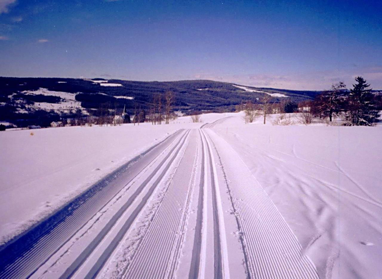
photo: Newly groomed trail through Vardal
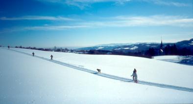
photo: Trail through Vardal
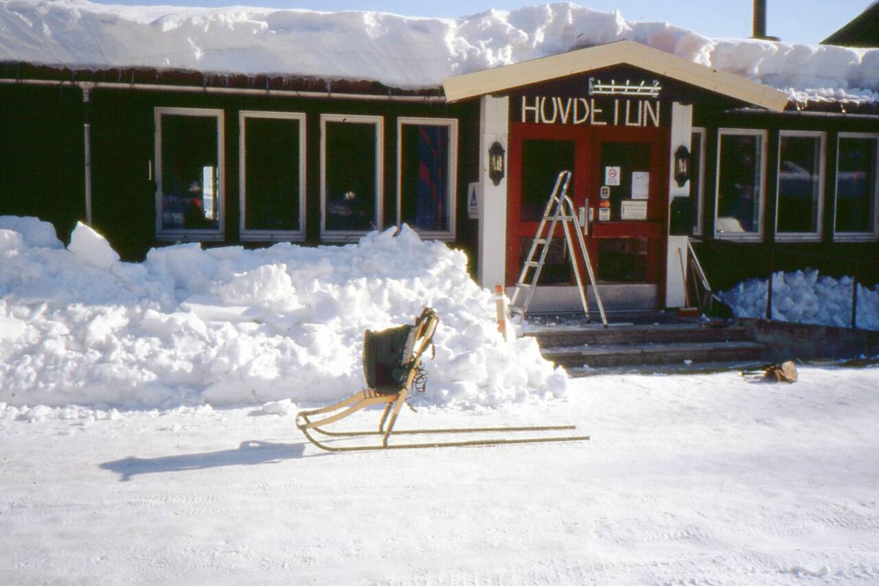
photo: Hovdetun and spark, Gjřvik
Back to index
David Dermott , Wolfville Ridge, Nova Scotia, Canada
email: david@dermott.ca