Notes: I use the word "spark" for the Norwegian/Swedish
"sparkstötting" which is usually translated as "kick-sled"
For a description of spark see: Spark
"Kommune" is a municipal subdivision of a "Fylk" or county. Corresponds to a "township" in eastern US and Canada.
Norwegian "løype" (or "løipe") means ski trail. The word "loipe" has been borrowed by German and Dutch and maybe English.
"Hytt" means hut, cabin or cottage but can be a rough shack to a fancy mountain hotel. "Stue" is also means cottage.
"Myr" means mire, moor, bog. Boggy uplands with few or no trees
"Vidde" ("wide open space") is mountain plateau above the treeline
Here is a map of the ski trails north of Hamar Skikart Hedmarksvidda
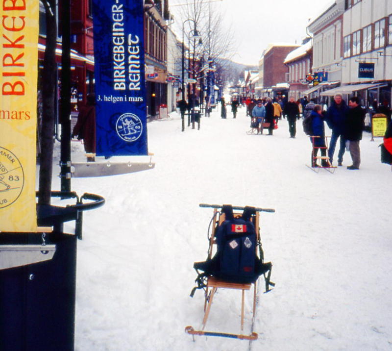
Here is a picture of Main street in Lillehammer
OBS! NOTE! This is just a rough draft, there's lots of spelling and other errors. I hope I can correct it soon!
The streets and sidewalks in Hamar were extremely icy. I was glad I had my ice-grippers, but I wished I had a spark. Several people passed me on sparks as I krep along the 2 km to the motel/hostel next to the Vikingskip arena. The arena is huge, it can be seen from across the lake about 20 km away. It's one of the best indoor speed-skating arenas in the world. But now it didn't have any ice, there were having a big show in it for Hamar's 150 year anniversary.
There was a new guy working at the hotel. I asked if there would be city busses going to Gåsbu on Saturday, he checked and it seemed that the city busses only went up there Monday to Friday. I asked about renting or borrowing a spark, he thought there was an old spark parked behind the motel.
I decided to ski back downtown on the cove (Åkersvik) and check at the tourist bureau. There were several paths down the bank to the cove, and several ski tracks on the ice. I could get almost to the railway station, but there was a high fence and a railyard of 20 tracks betweem me and the station. I left my skis and walked down to an underpass, then back to the tourist bureau. I met Liv , who was manager at the motel 3 years ago, and remembered me!. "So are you here to do the Birkebeiner again?" In 1995 Liv had been very helpful in finding out how to catch the bus from Hamar to Rena for the Birkebeiner. She confirmed that there were no city busses running to Gåsbu on the weekends.
If I had been here last weekend I could have joined up with the local chapter of DNT (Norwegian hiking group) who were organizing a tour from Sjusjøen to Gåsbu (52 km).
I had bought a new trail map of Hedemarksvidda - a 50000 scale topo map with most of the loipes marked. It showed 2 loipes going from east Hamar to Vangåsen near Gåsbu. But the map ended about 2 km north of Vikingskip. The first part of the loipes cross open fields and there are usually lots of other ski tracks. So I just had to find the start of the loipe.
Then I return on Åkersvik under a few bridges and along the marshy area along Flagstad Elv (river). I saw several ski tracks on the hillside fields but these turned off. The snow in the fields had a light crust but it was easy breaking trail. My violet wax was working but would probably wear off in this coarse snow. I saw more tracks , and this turned out to be a double track, groomed by a snow-cat groomer. I followed it back to a junction marked with a sign for Øst and Vest Ås. This is exactly what I'm looking for, both branches go up to Vangåsen, I think I'll take the western branch tomorrow. Then I followed the trail back towards town.
The groomed trail ended right at the river bank. It looks like there had been a bridge here, years ago. There were ski tracks, side stepping down the bank, then across the river, and up the other bank. It also looks this trail had been here long before the new E-16 highway was built. But there is a pedestrian tunnel under the highway, and I don't even have to take my skis off. The ski tracks went up a hill, towards a residential area, but I cointinued along the river marshes back to my outgoing tracks. It was a quick trip home form there. So now I know the route to Vangåsen.
Back at the hotel I was eating supper in the kitchen, when Ian from England arrived. He had been forced to leave Lillehammer by the thousands of women who were arriving for the weekends Inga Låmi. He wanted to know about the trails I had found and was interested in following me for a while tomorrow
I left with Ian around 0900. He said he had only been skiing a few times, so would only follow me for an hour or so. It was a fast, easy trip on my old tracks along the marshes. We took the west branch at the junction. Ian continued for a another couple of km, then he said he might explore the east branch on his way back. One can see the Vikingskip arena.
There are several road crossings. At the first one, the road was bare so I had to take my skis off. The next few roads were ice so I could carefully cross on skis. Then higher up the roads were snow covered, so it was easy crossing. There was always a dip of at least 100 cm at each road, at the groomed trails it was usually a gentle incline. There was a problem if I skied across UN groomed fields and came to a road crossing, where there would be a small "cliff" on both sides of the road.
The tracks were crusty up to about 300 m, but my violet wax gripped well for a while. The crust had worn off much of my wax, so at a snack break I put on some more violet on. I should have waited 5 minutes. I was soon in good powder and had too scrape the wax off again!
After mostly open farm fields, there are more and more woods. I only met a few skiers on the climb. By the time I reach 400 m there is a excellent trail in perfect snow. The trail climbs 100 m in the next km. It crosses an unplowed road and will miss Gåsbu, so I decided to take the road for 3 km towards Gåsbu. It was easy breaking trail, but after about 500 m , I met someone else's tracks. I also saw signs of a recent "kill". It appeared that a grouse or ptarmigan (rype) had buried itself deep in the snow (about 50 cm down) A predator had dug down and eaten it. There were just feathers left. The tracks were small, so I think it may have been a wolverine (jerv)
The road led to Ormseter, where I had cycled past in 1996. There I met a groomed trail again, and passed the entrance to the dogsled courses. Then I crossed a series of wide trails, groomed for classic and skating. These are part of the Gåsbu Langrenn senters competition trails. According to a sign, the Norwegian National Championships will be held there in 2000.
Then I come to the Gåsbu parking lot. It looks like everybody in Hamar is here today! No surprise because the conditions here are always excellent. Gåsbu is at 500 m and the trails go up from there, so there is usually dry powder snow from late November to late April, so I've heard.
The big restaurant is open, but I ate my lunch outside. Then I started up on the main trail, but turned off on a parallel trail. There may be thousands of people here, but the with the size of the area it isn't crowded after th first 500 m. Vangåsen is the southern edge of Hedemarksvidda, which goes all the way to Rondane. About 30 km to the north, the Birkebeiner Løype crosses the region. Several trails from Gåsbu cross the Birkebeiner, including the 52 km trail to Sjusjøen. There it continues as the Troll Løype for another 150 km to Rondane.
The trail climbs steadily, but conditions are so excellent I hardly notice it. Too bad the sun wasn't shining. It was misty with light snow. But it gives a eerie but beautiful mood as ice-crystals form on the pine branches. I think this what they call a "trollisk" scene. The pine woods became very open, then at the summit of Stenfjellet, it was almost open vidde. Then I checked the map for the altitude. It was 750 m, and I had started the day at 120 m! Treeline here is around 900 m.
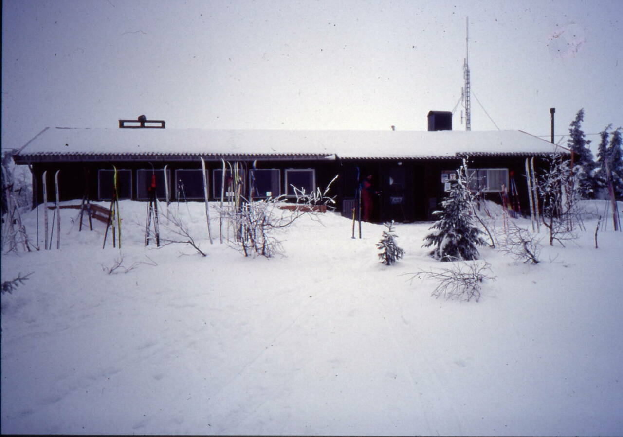
So I cut across to the restaurant at Stenfjellhytta, which is run by Hamar And Hedmarks Turistforeninngen, the local branch of DNT. I had the customary solbaer toddy and vaffle. like silk The trip back to Gasbu was a blast. It is a straight 4 lane trail downhill, so I just stayed in the tracks and coasted down the 6 km in about 10 minutes
Photo: Stenfjellhytta Mar 13 1999
See also: WEBCAMERA at Stenfjellhytta
I took the same track back to Hamar. It got crust below 300 m, but there were no problems. Back on the river flats I noticed a few tracks coming back to my tracks, so I suspected Ian had gone exploring a bit.
I borrowed the old spark for a quick trip , about 2 km return, to a shopping center to use a mini-bank About 42 km skiing, with a total climb of 800
When I got to Lillehammer it was still snowing. I left my heavy pack in a locker in the station. The station was packed with women, some were wearing traditional "bunad", some in funnier costumes. The Inga Låami race is more of a fun thing, although some of Norway's top female skiers compete in it.
I walked a few blocks to Gjestebu. They would have room tonight, they were of course full with women Friday and Saturday nights. I decided to ski across town to Maihaugen, the open air museum. I could ski up side streets (Marius Thrane and Lysgardvegen) to the field beside Håkans Hall. Then I got on the main loipe towards Maihaugen. There are a few steep hills on it, but I saw some very young children skiing on it. It goes through a residential area of town. Then there is a steep, narrow ungroomed side trail to Maihaugen, But with 10 cm of new snow it is no problem going down.
I found out that admission to the outside area of Maihaugen is free. The tourist brochure had mentioned that they had sparks for visitors but apparently they have all been stolen! It would have been very "traditional" to tour through the streets of this old town on a spark. I walked a ways, but it was snowing heavily so I couldn't take many pictures. There were several spark tracks on the streets, I guess people bring there own.
So I put my skis on a skied up the steep trail to the main trail. Then I took a new route up the hill on a nice wide trail. There were a lot of children coming down, with racing numbers and medals. Today had been Birkebeiner Barnsdag up at the ski stadium.
The loipe crosses the Mesna canal and joins the Birkebeiner loipe about 2 km from the finish. At the stadium, there is final S-bend and I picked up speed to cross the finish line (Mål). HEIA! HEIA! I looked up at the scoreboard for my imaginary time- did I beat Jevne or Daehlie?!
I was going to have a hot drink at the kafee but it closes at 1500. It is also not open on Monday or Tuesday. So I just ate a snack outside. It was an easy trip down in the fresh snow. The ski stadium is at about 500m, Stampesletta - the field beside Håkan Hall is about 300 m, and my hotel is about 200 m. There is usually a nice view of the town, Mjøsa and Gudbrandsdal but today it was foggy.
The trail comes out of the woods at the base of the ski jump and then goes down across the big field of Lysgård towards Håkan's and Kristin's Halls. This was the field where the opening ceremonies of the 1994 Olympics happened.
The field beside Håkon Hall is a ski playground so one has to be careful following a ski track. Often it will go over a large jump. I have seen children doing some graceful jumps on narrow light touring skis.
I could ski most of the way back. I then walked back to the station to pick up my big pack. I asked the guy at Gjestbu about borrowing a spark. They didn't have any left -all stolen! He thought the city had a service center that supplied sparks to visitors.
"It's free!"
 "Do you want a deposit or my name ?"
 "No, just bring it back here when you are finished"
WOW. I better take good care of it. So I "went native" on the streets of Lillehammer, using the spark to go shopping. I even impressed a few American tourists! I had a bicycle cable lock so I locked the spark up, everywhere I stopped. I noticed most people in Lillehammer now lock up their sparks.
It was 1400 before I got back, made my lunch and got skis ready. I decided I would stay in Lillehammer a few more days. I could ski most of the way to Håkan Hall on the sidewalks. The field there, Stampesletta, had been groomed for sledding, ski-jumping etc. It was easy climbing up the big field below the big ski-jump (This is where the Olympic opening ceremonies were) The temp was about -3, it was cloudy with no precipitation. At the ski-shooting area (I guess it's called "biathlon" in North America!) there was some race going on. The Birkebeiner ski-kafee is closed today. I won't have time to get to Sjusjøen today so I headed up towards Nordseter via Skurvbrua (600 m).
The trial to Flømyra (640 m) has been recently groomed. I turned off a a trail with about 10 cm of fresh snow on it. There were recent ski tracks so it was still easy going. The area becomes more open bogs (myr) as the elevation rises to about 750 m. Another 150 m and it would be all open terrain. There is no wind and in the fresh snow my skis make a very light hiss. When I stop, I hear nothing it is very silent. Some skiers passed me while I stopped, but I couldn't hear them until they were right beside me. The scene is very "trollisk", small fir trees covered in snow do look like trolls.
I decided I'd better turn back, after a light snack around 1700. I was about 2 km from Nordseter. The way back was much quicker than I thought -it is over a 500 m descent, after all! I was back at my room in less than a hour!
I got on the spark and headed downtown to the library but it had closed. Most of the stores on Gågate were closed and there were very few few people on the street so I got a chance to speed along in excellent sparking conditions.
It had snowed another 10 cm overnight, and was still snowing. It was fairly mild and my skis kept clogging up. I could ski all the way up, I didn't even have to take my skis off crossing the main streets.
I passed the Ski stadium on to the main Birkebeiner trail towards Sjusjøen. They had put up signs at each km before the finish line for Saturdays race. The skiers I met on this trail were very different than most I had seen in Norway. They didn't look or ski like Norwegians. There are a lot of foreign tourists here, some Brits, some American, some Germans, but mostly Danes. It is the winter school break week in Denmark. There are a lot of jokes about "Danes on ski". Probably the Norwegians think I am a Dane! Every now and then, a faster skier would past me, with "Lillehammer Skiklubb" on the backs of their jackets.
It continued to snow, the wind was in my face and I was getting wet. The trail climbs continuously, with a few steeper sections. There is even a small slalom hill with ski lift about 2 km before Sjusjøen. At Sjusjøen (840 m) it is mostly open area, with low visibility today. There are dozens of roads and thousands of huts so it is confusing. The Birkebeiner route is marked with red poles but I turned off looking for the restaurant and sports shop. They were hidden behind a huge snow pile. I almost went over a 3 m high cliff down to the parking lot!
I went into the cafe and tried to dry out a bit. I think the window overlooks the lake and the open vidde but I can't see a thing today. There's no point in continuing out in the open.
I noticed that the sports shop was renting sparks for 50 kr a day
On the way back I had the wind behind me and when I got back into more sheltered trails I felt much better. So I decided to take longer way, via Mesnasaga (520 m) at the end of Mesna lake. Actually this is the Inga Låmi trail. There a nice flat scenic section along the open Mesna river. Then I joined the trail I came up on on Sunday for a fast descent to town near Maihaugen. Then back to the field by Håkans Hall. With all the fresh snow I was able to ski on the streets almost all the way back to Gjestebu.
I took the spark out for a cruise around town, and down to the railway station to get a ticket to Tynset.
I changed trains in Hamar, with an hour wait. Wet snow overnight , and snow continued for a while in the morning but then it started clearing further north in Østerdalen. The train passed by Rena, which was getting ready for Saturday's Birkebeiner start.
I was heading for Tynset, 500 m elevation, latitude 62, in northern Østerdalen. I hoped it would be cooler and drier up there. The information about Tynset in the Norske Vandrehjem handbook (hostel) sounded interesting; "many opportunities for outdoor activities,..., miles (Nordic mile = 10 km) of prepared ski trails , world's largest spark ...". My adventures are just beginning!
(to be continued)
Back to index
David Dermott , Wolfville Ridge, Nova Scotia, Canada
email: david@dermott.ca