Yarmouth is the gateway to Nova Scotia for many cyclists arriving on the ferries from Bar Harbor ( 6 hours) or Portland ( 12 hr). There are lots of nice rides in the area such as:
If you are doing a loop via South Shore , Cross-Province roads and Annapolis Valley it is better to go counter-clockwise . You get a better view of the coast going that way and the barren sections of Rt 103 near Shelburne are wicked in a headwind ( SW normally).
30 km There is a nice beach at Mavilette , the water is cold. About 10 km further there is a scenic picnic park at Smugglers Cove near Metaghan. This the district of Clare, an Acadian French area with unique culture. The prominent landmarks are the HUGE churches at Church Point and St Bernard. There are very few trees along here so there is no shelter from the wind.
70 km The New Edinburgh Road near Weymouth is one of the nicest sections, on a clear day one gets a good view of Digby Neck. One can access Rt 101 and the Weymouth Hbr. Bridge rather than backtrack into Weymouth.
Traffic now gets heavier as we must follow Rt 101 which does have a shoulder. At Brighton the unpaved Marsh Road is a shortcut to the Digby Neck route.
100 Km Digby ( see Annapolis Valley Chapter)
67 km At Weymouth Falls the paved road goes into Weymouth. A good gravel road goes to South Range and Bear River. The last section is paved and descends a steeply into the scenic Bear River Valley.
100 km From Bear River to Digby follow east bank which is flat. All other roads out of the village are very hilly .( See Annapolis Valley Chapter)
10 km Dirt road crosses the marshes at end of St Mary's Bay. This is a shortcut to Rt 1 at Brighton.
15 km the first big hill starts at Rossway- 100 m climb.
23 km road to right leads to store in Centreville. Just after this there is a picnic ground and beach at Lake Midway. Then it's downhill to scenic Sandy Cove (32 km). There is a small store at Little River. Then there is a switchback descent down to the ferry landing at East Ferry.
48 km The ferry usually runs every hour but if it is full they may make extra runs. The tidal current is very strong here. Tiverton is a nice fishing village . There is a whale watching cruise leaving from here.
50 km On the left there is a trail down to the balancing rock. It is about a 45 minute return walk. The last bit down to the cliff is rather steep, there is a rope to hold on to.
55 km There is a campground near Central Grove and a restaurant and store a little further along.
64 km Freeport . There is a small store and bakery here. The ferry for Briar Island leaves every hour. It can be rather cool and foggy out here. There are more whale watching cruises leaving from Westport. This is also a popular spot for birdwatching. There are several spots for camping on the island but beware of high winds in the open fields by the shore. Herds of sheep wander at will around the island.
10 km Just east of the Tusket river a nice paved road goes to Tusket Falls ( 3km) where there is a good swimming spot . This road continues along Lake Vaughn to Reynarton and is a good route to the Ellenwood Provincial Park campground. To the west, Tusket Bay with hundreds of islands can be seen.
25 km Glenwood Provincial Picnic Park is on small lake. This region, Argyle, is another Acadian area. Rt 3 goes by many fishing villages, the Pubnicos, Wood Hbr., Shag Hbr.
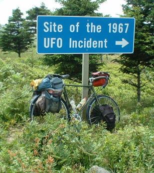
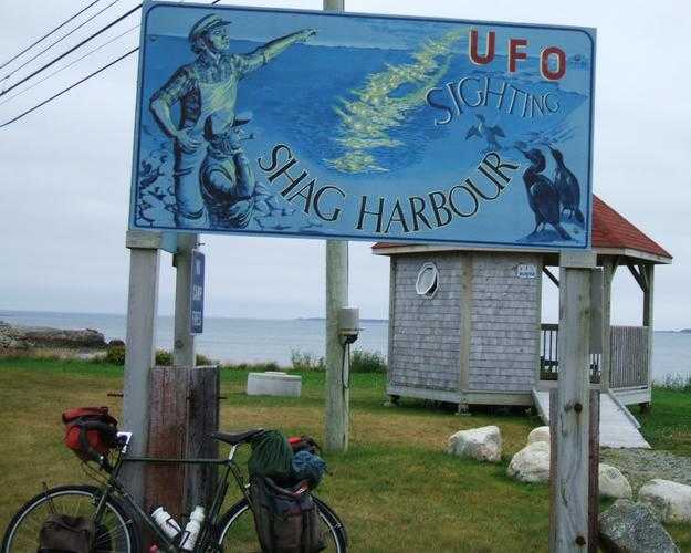
In Oct 1967, a UFO landed and sank in Shag Harbour. Many people,
including the local RCMP saw this. There is now a little picnic
area on the shore near the site.
There is some information about it in the local
museum at Chapel Hill.
photo: UFO crash site near Shag Harbour
photo: UFO crash site picnic area near Shag Harbour
80 km At Barrington Passage road leads across to Cape Sable Island, the most southern point of Nova Scotia, also one of the foggiest. There is a big grocery store in Barrington P.
88 km Barrington, right to Port Latour. Rt 103 from Barrington to Liverpool is very boring , passing through rocky bogs and only coming near the sea at the heads of bays. Traffic isn't very heavy and there is a paved shoulder. It isn't very hilly but there trees are very scrubby and offer little shelter if there is a headwind, which usually blows from the southwest in fair weather. The loop roads off of it offer slightly better scenery. One is tempted ride quickly on Rt 103 to Liverpool where the good stuff begins.
25 km At Clyde River Rt 103 is a shortcut. The road around Roseway adds about 20 km and is more scenic.
60 km Rejoin Rt 103 for a short distance, then exit at Birchtown and come into Shelburne. There is a Provincial Camp Ground just before the town.
67 km Shelburne is a fair size town with grocery and hardware stores. Go out of town on Rt 3 , then right on the Jordan Branch Rd. to Jordan Falls. Rt 103 is again desolate. Rt 3 via Lockport isn't right on the coast most of time either and adds about 20 km.
91 km At Sable River the only road is Rt 103 and it is again boring. The highway touches the heads of bays at Port Hebert, Port Joli and Port Mouton.
117 km: At Summerville Beach the scenery improves. There is a picnic ground at the beach but parts of it may be closed to protect the nesting grounds of the piping plover, a rare shore bird. There are several resorts along the shore here.
135 km Liverpool is a major town with motels, restaurants and stores.
Start off on Rt 3 to Brooklyn. There you could follow Rt 3 to 103 and then to Mill Village, a shortcut of about 13 km. But this first loop is quite nice. Turn right on the Beach Meadows Rd. There used to be a camping area at the beach, which is just off the road. Then we go through West Berlin where a side road leads to East Berlin. There is no wall. Then we come to the mouth of the Medway River .
25 km Right on Rt 103. We could go straight to scenic Mill Village and loop back to Rt 103. From Mill Village there is also a scenic road along the river to Greenfield( described in another chapter).
27 km Right on Rt 331 (or cross Rt 103 if taking loop through the village) Now we go through the scenic fishing villages of Voglers Cove, Cherry Hill and Broad Cove. The view approaching Broad Cove is one of the best on the shore. There is a rather steep downhill to the bridge at Petit Riviere. This is Lunenburg County which has lots of drumlins, steep oval hills left by the last ice age.
57 km Rissers Beach has a Provincial Camp Ground. It can be quite crowded on weekends. This is a more sheltered bay and in August the water may sometimes even be warm! Just a little further Crescent Beach leads to the first of the Lahave Islands. This is popular ocean kayaking and canoeing area, there are some nice sheltered bays among these islands. There is a general store near West Dublin. There is another great view along the Dublin Shore. The site of an early French fort is at the mouth of the Lahave River.
67 km Lahave ferry. Here there are several options: (1) continue along the west bank of the Lahave to Bridgewater; (2) cross on the ferry and go to Bridgewater on the east bank; (3) cross the ferry and go to Mahone Bay via Rt 332.
While we are deciding we will stop at the Lahave Bakery, one of the best in Nova Scotia. Cyclists have been known to miss several ferries while pigging out here! There is also a Youth Hostel above the bakery. Often there will be large sailing ships docked at the wharf. The ferry makes regular hourly crossings ( on the hour from this side) but may make extra crossings if there is an overflow. It is free for bicycles and pedestrians. Turn right if going to Mahone Bay. There is a shortcut on Indian Path , bypassing Riverport. It has osprey nests along it.
There are stores in Riverport and Rose Bay. At the latter there is a paved road leading to Kingsburg Beach ( nice beach but COLD water). Road to right goes to Ovens where there is a campground and interesting sea caves. Rt 332 goes along the scenic South Cove. There is another campground at Bayport. Rt 332 skirts around the town of Lunenburg to join Rt 3. There are at least 4 roads into town, the first is the most scenic.
80 km Right at First South on Corkum Island- Mason's Beach Road. This climbs a drumlin to the golf course where there a great view of the town.
Lunenburg is quite a popular tourist spot so expect crowds. An interesting diversion is the 15 km round trip to Blue Rocks and Stonehurst. The town is built on a drumlin between two harbours so many of the town streets are steep.
83 km ( distance assumes town was bypassed) Head out of town to Rt 3. At Martins Brook Sunnybrook road to right is scenic little road to Maders Cove, only adding about 2 km.
93 km Mahone Bay ( THE TOWN ) is one of the most photographed towns in Nova Scotia. At the main corner there is one of the best produce markets in the province. At the head of the harbour , the Indian point road gives a good view of the town. This loop only adds about 5 km and rejoins Rt 3 near Martins River. There is a campground just off the highway up the river road.
At Western Shore the highway is right along the shores of Mahone Bay ( THE BAY). One of the hundreds of islands in the bay is supposed to have buried pirate treasure. People have been digging on Oak Island for over 100 years with no luck!
108 km At Chester Basin Rt 12 leads to New Ross and Kentville. There are some steeper drumlins on Rt 3 past Chester. Just before Chester Rt 14 leads to Windsor.
116km Chester is a very popular summer home for the sailing crowd. Just past the town is Graves Island Provincial Park, where there is very scenic campground which is often full on weekends. There is an overflow area for cyclists and groups can reserve a secluded area. There are some more steep but short drumlins before East River.
10 km RIGHT on Rt 329. DO TAKE THIS! This is the nicest route on the whole shore and is still not very crowded. It is much nicer than Peggy's Cove. This is a fairly popular century ride ( 160 km) from Halifax. First the road follows a deserted beach, then it makes a long climb with some nice views of the bay. Then there is a quick descent to fjord-like Deep Cove, then another short hill and back down along the shore to the fishing village of Blandford. There is a nice restaurant and general store called "The Deck" Next is Bayswater Beach where there is a picnic area. This is on the open ocean so the water is very cold. The road makes sharp turns around the coves in the two very scenic villages of Aspotogan and North West Cove.
Then we are on the shore of St Margarets Bay. Before Mill Cove take the unpaved but smooth Shore Road which goes right along the wharfs of this fishing village. If you miss the first turnoff there is another one a little further on. There is a small beach at the north end of the village, where the water is warmer than at Bayswater. Then we rejoin Rt 329. There is a short steep hill then it's back down the shore at Fox Point.
Coming into Hubbards the road forks, take the right branch . There is little bakery on the shore.
50 km Join Rt 3. Just across the street is Debby's Dinette, a quaint cafe that makes great bagels. There are grocery stores and a hardware store in a little mall in the village. Rt 3 is quite scenic along the top of St Margarets Bay but gets busy on summer weekends since it is close to the city and the most popular beaches are here. The biggest beach is Queensland. It is quite sheltered and often gets warm in late summer. It is very crowded on weekends. In September it is almost deserted and the water is the warmest. There are several smaller beaches near by, Cleveland Beach has a picnic ground.
After the end of the Bay there is a small shopping center at Tantallon. there is a nice Natural Food store here. The Peggy's Cove road , Rt 333, goes to to right here. Peggy's Cove gets very crowded.
To the left Rt 213 leads to Bedford, bypassing the city. It is called the Hammonds Plains Road but plains means flat and it isn't flat! This road, then Kearney Lake Rd and Dunbrack Street are an alternate route into parts of the city.
Rt 3 goes through increasingly suburban areas of Timerlea, Lakeside and Beechville and enters Halifax. There are very few roads into the city so traffic can be very heavy. Rt 3 comes down a steep hill which may have potholes, sewer grates, and hidden driveways . At the bottom of the hill is the infamous Armdale Rotary - a traffic circle or round-about, which can be very confusing. The best approach is to stop and walk across on the cross walks when you find which street you want to take.
There are several very good bike shops in the city such as Trail Shop (Quinpool Rd), Cyclesmith (Quinpool Rd) and Jack Nauss ( Willow and Robie) ------------------
If going north , take Rt 102 from the airport for about 6 km to Enfield and on to Rt 2. IRVING BIG STOP at this corner has restaurant and general store. There is a campground at Laurie Park on Grand Lake. Oakfield Park is just a picnic area.
If going east from airport, turn left on Rt 212. Plane watchers will like this since the road goes along the runway. There is a nice Provincial Park with campground and beach on Dollar Lake ( 20 km) but there are no stores until Elderbank (30 km).